Heritage Foundation of
Chesterfield Missouri
Chesterfield's Online Museum
Scroll Down to Explore - From Oldest to More Recent History

12,500 Years Ago - First Known Inhabitants
The first known inhabitants of Chesterfield were mastodon hunters who set up a hunting stake out on a tall hill overlooking a watering hole. The watering hole was located in present-day Faust Park, and the hill is now Nooning Tree subdivision. Chesterfield resident Dick Martens discovered and first documented the site, which was later excavated by archaeologists from Washington University. The site, the Martens site, was named in his honor.

4,000 Years Ago - First Known Artwork
This star etching was made on a stone weight used on a spear thrower (atlatl). It was found at a 4,000 year old village excavated in preparation for construction of the Countryside at Chesterfield subdivision, near the Long and Wild Horse Creek roads. It was named the Hayden site, in honor of builder Dennis Hayden who alerted archaeologists to the presence of the site.

2,000 Years Ago - Village at River Bend Elementary
Chesterfield resident Dick Martens discovered a 2,000 year old village during construction of the River Bend Elementary School in the fall of 1968. The site yielded evidence of three innovations adopted by the people of the site: use of pottery, gardening, and the bow & arrow.


800 Years Ago - Chesterfield a Suburb of the Mound Builders of Greater Cahokia
Chesterfield has many ancient burial mounds (earthen pyramids), including Blake Mound, the largest surviving Native American constructed mound in St. Louis County. The mound was built on the bluff top directly above a cave in the base of the bluff. A large village/market center/ceremonial center was discovered by Chesterfield resident Stan Dampier in the valley below. It was excavated, revealing a large village. On the morning of the Winter Solstice, when standing at the doorway of a temple, the sun appears to rise directly out from behind Blake Mound. Other celestial alignments were associated with another mound on the opposite side of the river. This site and others were affiliated with the mound building culture of Greater Cahokia - a massive city that stretched from Cahokia Mounds State Historic Site, across East St. Louis, all the way to present-day St. Louis.
Click Here to Learn About River Bend Estates Site
Click Here to Learn About an 800 Year Old Farmhouse in Faust Park
Click Here to Learn About Blake Mound
Click Here to Learn About the Dampier Site
Click Here to Learn About Cahokia
Click Here to Watch a Brief Video About Cahokia
Click Here to Watch a 30 Minute Documentary About Ancient St. Louis
.jpg)
1714 - First European Explorer
Though Marquette and Joliet had noted the Missouri River at its confluence with the Mississippi in 1673, the first to explore the Missouri River, passing through this area, was French explorer Sieur de Bourgmont in 1714.

1798 - First Town Established in Chesterfield
Scottish fur trader James Mackay established the village of St. Andrew near the river. The town had over 300 residents, but had to be abandoned after just a few years because the river began meandering in its direction.

1804 - Lewis & Clark
After starting their exploratory journey downriver at St. Charles, the Lewis & Clark expedition spent their first night camped on an island in the area of Chesterfield.
Click Here to Learn More About Lewis & Clark
Click Here to Watch a 1 Hour PBS/Ken Burns Segment on Lewis & Clark

1815 - Town of Chesterfield Established
Col. Justus Post arrived here by boat and established the small town of Chesterfield near Wild Horse Elementary School.
Click Here to Learn More About Justus Post
Click Here to Learn Even More About Justus Post

1819 - First Steamboat
A Chesterfield farmer heard the whistle of the first steamboat to pass by and thought it was the scream of a crazed mountain lion!
Click Here to Learn More About Steamboats
Click Here to Learn Even More About Steamboats and the Missouri River
1824 - 2nd Governor of Missouri

Frederick Bates, the 2nd governor of Missouri, lived at a home in present-day Faust Park. Everyday, he commuted to the State Capital, which was located at that time in St. Charles, by riding his horse to the river and crossing to work in a boat.
Click Here to Learn More About Governor Bates
Click Here to Learn About Governor Bates' Home in Faust Park

1863 - Chesterfield and the Civil War
A Union cannon battery kept watch for Confederate ships plying the Missouri River, which flowed much closer to the bluffs at that time. It was located near the Dierbergs Headquarters.
Click Here to Learn More About St. Louis and the Civil War
Click Here to Learn Even More About St. Louis and the Civil War

1895 - Rail Road Station in Chesterfield
A postal station was established in Chesterfield on January 31, 1895. Mail arrived at the station and then was delivered to homes and businesses via horse back. As the flow of mail increased, it was delivered by horse and buggy.
Click Here to Read a St. Louis Post-Dispatch Article About Rail Road History in St. Louis.

1925 - Chesterfield's 1st Fire Protection
The earliest know fire protection, the Bellefontaine Volunteer Fire Department, was established in 1925.
Click Here to Learn About the History of Fire Protection in St. Louis

1930s - Telephone Service in Chesterfield
Telephone service first came to Chesterfield in the 1930s, first operated out of the Chesterfield Bank Building.
Click Here to Learn About the History of the Telephone
Click Here to Learn About the History of the Telephone in St. Louis

1943 - WWII P.O.W. Camp in Chesterfield
Italian, German, and Austrian prisoners of war were imprisoned at Camp Chesterfield from 1943 to 1946. The camp was located on the south side of Chesterfield Airport Road, just west of Long Road.
Click Here to Read a St. Louis Post-Dispatch Article About P.O.W.s in St. Louis/Chesterfield

1964 - The Spirit of St. Louis Airport Opens
Chesterfield's airport, the Spirit of St. Louis Airport, opened on November 6, 1964. Paul Haglin, the man who first dreamed of adding an airport in Chesterfield, was the first to use the airport, landing his small Cessna 195 airplane at 3:45 p.m.
Click Here to Learn About the History of the Spirit of St. Louis Airport
Click Here to Learn About Where the Airport Got Its Name
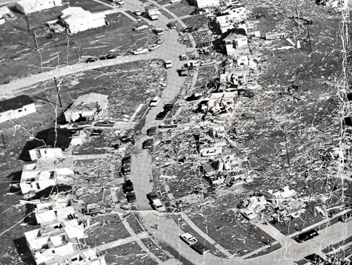
1967 - Tornado Hits Chesterfield
An F4 rated tornado touched down in Chesterfield at 6:00 p.m. on January 24, 1967. For nearly an hour it made a path of destruction through Chesterfield, Maryland Heights, and onward across North St. Louis County.
Click Here to Learn More About the Tornado - National Weather Service

1988 - Chesterfield Incorporates as a City
A vote to incorporate Chesterfield as a distinct municipality passed in 1988.
Click Here to Explore the City of Chesterfield, Missouri's Website

1993 - The Great Chesterfield Flood
On July 30, 1993, the levees along the Missouri River protecting Chesterfield gave way, filling the entire valley with up to 10 feet of water. As with previous floods, the resilient residents cleaned up, rebuilt, and carried on.
Click Here to Watch a Video About the Chesterfield Flood of 1993
Click Here to Watch a KSDK News Video About the Flood of 1993
Click Here to Read a St. Louis Post-Dispatch Article About the Chesterfield Flood of 1993